
Geo-referencing as Foundation
Since mapping is the basis for restoring locations of events from the past, if at all possible a "canvas" on which to display historical information and make it accessible is a highly desirable first step.
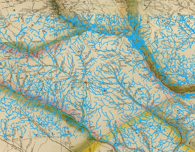
Illustrated here is a geo-referenced map taken from the 1822 surveys and published by Tanner in Philadelphia. It has been cast to UTM Zone 17 and NAD27 coordinates by use of modern hydrological features from the USGS. The hydrological features, while not immutable, change only occasionally at one place or another. The usual problems of using scanned images from atlases is visible here, since the image while excellent is done from a published book.
Note in this image that while there is excellent general agreement of streams, creeks, rivers, etc. there are still areas of disagreement. Some come from the scanned medium (possibly stretched, patched together and so forth), some come from errors by the surveyors. Surveying with early instruments in areas difficult to penetrate speaks highly of the skill of the early mappers as demonstrated by the quality of the result.
To some degree we must be satisfied with solving most of the problem, if not all of the problem when faced with these facts.
Once the geo-referencing is done to some level of satisfaction, other features can be added such as GPS points, modern roads, etc., as the particular location under study is examined.
Currently this map, produced on Quantum GIS serves as the "canvas" on which to investigate the questions relating to the events and places of 1781 Orangeburgh District.
The current focus of georeferencing is the set of quadrant maps of South Carolina published by Tanner in Philidelphia based on the Wilson 1820 and after surveys of the state. All four have been completed and are available to the HRMC members. (Projection has been changed to (HARN) NAD83 datum and UTM Zone 17.) More up-to-date gis software can convert older, state provided, shapefiles, dlg's, vector data, rasters, etc., so a modern standard can be used.